The temp-2-stress project
What is temp-2-stress?
temp-2-stress is a research project funded by the German Federal Ministry of Food and Agriculture (BMEL) to analyze drought and heat stress in Central European deciduous forests using remote sensing methods. The acronym temp-2-stress stands for ‘Surface temperatures of deciduous forests for the analysis of drought and heat stress’.
Who is temp-2-stress?
temp-2-stress is led by Dr. Alexander Röll (University of Bonn) and carried out together with Simon Swatek (University of Bonn), in cooperation with Prof. Dr. Dirk Hölscher (University of Göttingen) as senior scientific advisor and project partners at the University of Twente and the Northwest German Forest Research Institute.
When is temp-2-stress?
The project duration is from November 15, 2024, to November 14, 2027. Drone flights, a central element of temp-2-stress, will primarily take place in the summer months of 2025 and 2026.
Where is temp-2-stress?
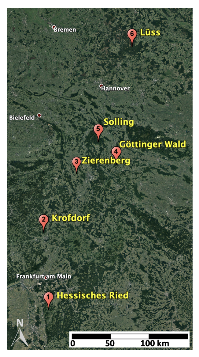
The investigations in temp-2-stress cover mixed deciduous forests on Level-II monitoring plots along a north-south gradient in Lower Saxony and Hesse (Germany), as well as complementary plots from a forest irrigation experiment in the Hessisches Ried region (SiZuRi project).
-
Hessisches Ried (Brown earth over carbonate-containing parent material): 8 plots
-
3 pairs of pilot forest irrigation plots and non-irrigated reference plots in oak-hornbeam mixed stands (SiZuRi project)
-
Level-II Monitoring Plot 611 ("Hessisches Ried Oak"): 113-year-old oak mixed stand with 30% beech and 3% small-leaved lime
-
Level-II Monitoring Plot 613 ("Hessisches Ried Beech"): 116-year-old beech stand with 2% hornbeam
-
-
Krofdorf (Brown earth over weathered/deck loam over clay): 1 plot
-
Level-II Monitoring Plot 609 ("Krofdorf"): 156-year-old pure beech stand; diagnosed beech vitality decline with heat and/or drought stress as a possible cause
-
-
Zierenberg (Luvisol over basic magmatites/metamorphites): 1 plot
-
Level-II Monitoring Plot 606 ("Zierenberg"): 164-year-old beech stand with 2% sycamore maple; diagnosed beech vitality decline with heat and/or drought stress as a possible cause
-
-
Göttinger Wald (Limestone brown loam over shell limestone): 1 plot
-
Level-II Monitoring Plot 306 ("Göttinger Wald"): 139-year-old beech stand with 6% sycamore maple and 3% ash
-
-
Solling (Brown earth over quartz-rich parent material): 1 plot
-
Level-II Monitoring Plot 304 ("Solling Beech"): 171-year-old pure beech stand
-
-
Lüss (Heath) (Brown earth over nutrient-poor Pleistocene sands): 1 plot
-
Level-II Monitoring Plot 301 ("Lüss"): 138-year-old beech stand with 30% oak (210 years old)
-
What is temp-2-stress about?
Central European forests are increasingly suffering from drought and heat stress as a result of ongoing climate change. This leads to a decline in vitality and increased tree mortality, which in turn results in the reduction or loss of important ecological, economic, and social forest ecosystem functions. Tree vitality and mortality, ecosystem indicators, and ecophysiological processes have been intensively monitored and studied on small-scale monitoring plots (e.g., Level-II plots) for decades. Modern remote sensing methods for measuring surface temperatures using drones and satellites offer additional opportunities to integrate these studies and further develop forest monitoring. In temp-2-stress, relatively large-scale yet high-resolution stress index maps will be created using drone and satellite imagery and will be made available through a user-friendly open-source workflow.
What are the objectives of temp-2-stress?
The main scientific objectives of temp-2-stress are:
- Developing remote sensing methods for stress monitoring in forest trees, including distinguishing between drought and heat stress in corresponding indices.
- Species-specific testing of the developed stress indices with small-scale reference measurements from project partners.
- Analyzing the influence of tree species (mixtures), site conditions, and forest management on drought and heat stress in the studied forest areas, also to derive specific climate-smart forest management concepts.
Which methods are used in temp-2-stress?
In temp-2-stress, small-scale ground reference measurements are combined with thermography and multispectral imaging from drone and satellite systems. This allows the study of drought and heat stress at tree, stand, and landscape scales.
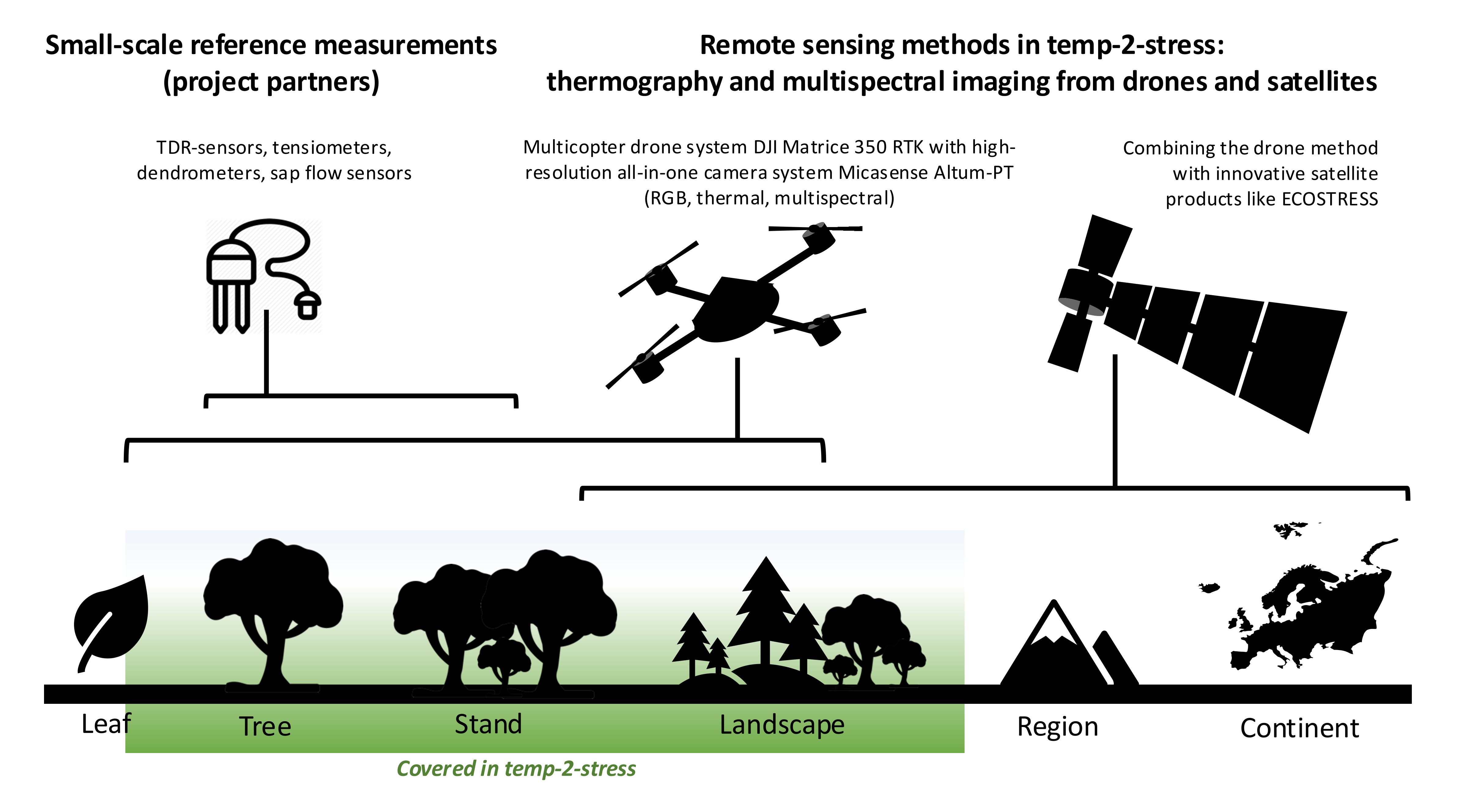
Ground reference
General site information as well as soil moisture, matrix potential, and tree growth are collected on the Level-II monitoring plots and SiZuRi research plots. On nearby open areas, additional climatic variables (air temperature, humidity, global radiation, precipitation, wind speed) are measured, which can be used to model potential evapotranspiration.
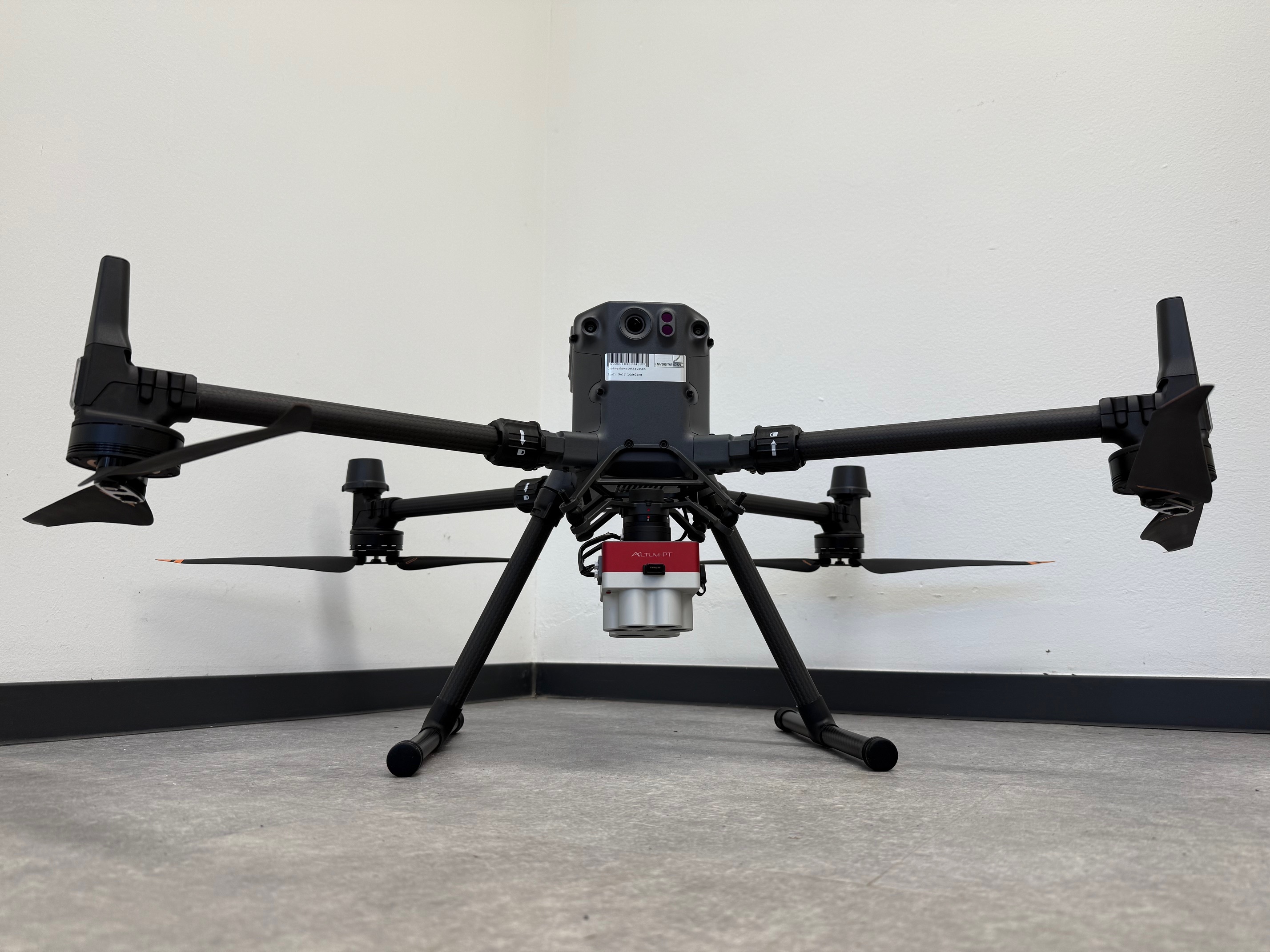
Drone flights
A DJI Matrice 350 RTK drone system is equipped with a Micasense Altum PT camera system (simultaneous panchromatic, multispectral, and thermal imagery). Additionally, an Apogee 4-component net radiation system is mounted on the drone. The thermal images and radiation measurements form the basis for modeling evapotranspiration and drought stress, while the multispectral images are used to assess tree vitality.
Satellite data
(including ECOSTRESS)
In parallel with the drone’s thermal imagery, the satellite product ECOSTRESS is used to investigate evapotranspiration and drought stress on larger spatial scales, with a spatial resolution of approximately 70 meters. A satellite equivalent of the drone’s multispectral data (e.g., from ESA) is also freely available. In addition to expanding spatial coverage, incorporating satellite data also extends the temporal coverage, as some satellite data go back many years.

Open-source workflow
The drought and heat stress analyses will be implemented in a user-friendly, largely automated workflow by the end of the project, using open-source solutions wherever possible.
temp-2-stress project activities
- November 15, 2024: Official project start
- January 17, 2025: Kick-off meeting with all project partners
- February 1, 2025: Project start for temp-2-stress PhD candidate Simon Swatek
- Currently ongoing: Integration of drone, camera, radiation, and stabilization systems
- Planned for March/April 2025: First test flights and system checks

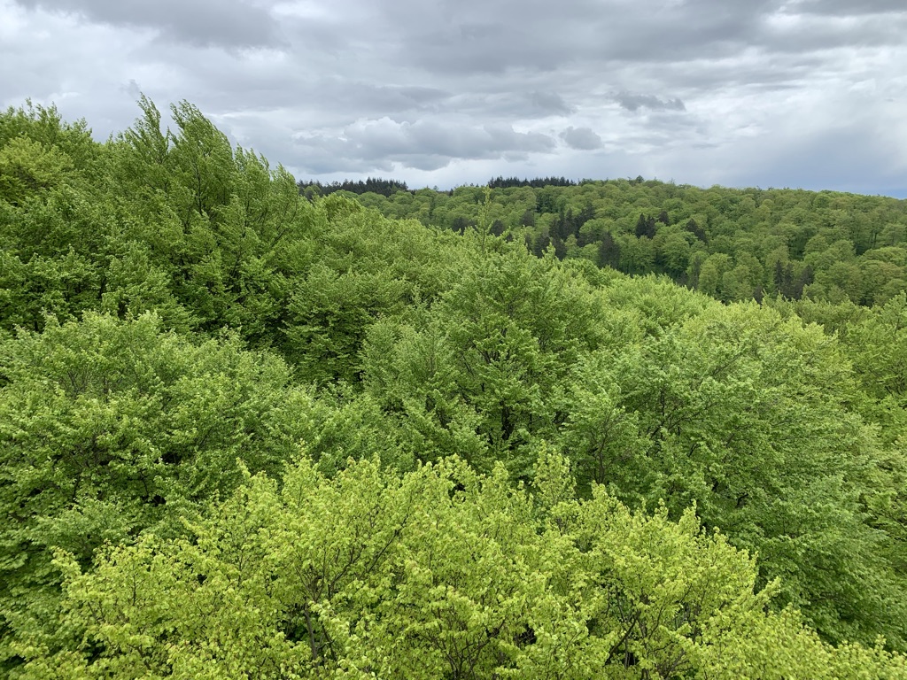
View of the beech canopy from a tower near the Solling research site.
Further Reading
- Ahongshangbam, J., Khokthong, W., Ellsäßer, F., Hendrayanto, Hölscher, D., Röll, A.: Drone-based photogrammetry-derived crown metrics for predicting tree and oil palm water use. Ecohydrology 12 (2019): e2115.
- Ahongshangbam, J., Röll, A., Ellsäßer, F., Hendrayanto, Hölscher, D.: Airborne tree crown detection for predicting spatial heterogeneity of canopy transpiration in a tropical rainforest. Remote Sensing 12 (2020): 651.
- Bulusu, M., Ellsäßer, F., Stiegler, C., Ahongshangbam, J., Marques, I., Hendrayanto, Röll, A., Hölscher, D.: UAV-based thermography reveals spatial and temporal variability of evapotranspiration from a tropical rainforest. Frontiers in Forests and Global Change 6 (2023): 1232410.
- Cortes-Molino, A., Valdes-Uribe, A., Ellsäßer, F., Bulusu, M., Ahongshangbam, J., Hendrayanto, Hölscher, D., Röll, A.: Combining UAV thermography, point cloud analysis and machine learning for assessing small-scale evapotranspiration patterns in a tropical rainforest. Ecohydrology 17 (2023): e2604.
- Dash JP, Pearse GD, Watt MS. UAV multispectral imagery can complement satellite data for monitoring forest health. Remote Sensing. 2018 Aug 3;10(8):1216.
- Ellsäßer, F., Röll, A., Ahongshangbam, J., Waite, P.A., Schuldt, B., Hölscher, D.: Predicting tree sap flux and stomatal conductance from drone-recorded surface temperatures in a mixed agroforestry system - A machine learning approach. Remote Sensing 12(2020):4070.
- Ellsäßer, F., Röll, A., Stiegler, C., Hendrayanto, Hölscher, D.: Introducing QWaterModel, a QGIS plugin for predicting evapotranspiration from land surface temperatures. Environmental Modelling and Software 130 (2020): 104739.
- Ellsäßer, F., Stiegler, C., Röll, A., June, T., Hendrayanto, Knohl, A., Hölscher, D.: Predicting evapotranspiration from drone-based thermography – a method comparison in a tropical oil palm plantation. Biogeosciences 18 (2021): 861-872.
- Fisher JB, Lee B, Purdy AJ, Halverson GH, Dohlen MB, Cawse‐Nicholson K, Wang A, Anderson RG, Aragon B, Arain MA, Baldocchi DD. ECOSTRESS: NASA's next generation mission to measure evapotranspiration from the international space station. Water Resources Research. 2020 Apr;56(4):e2019WR026058.
- Röll, A., Kang, T., Hahn, P., Ahongshangbam, J., Ellsäßer, F., Hendrayanto, Sharma, P., Wintz, T., Hölscher, D.: Complex canopy structures control tree transpiration: A study based on 3D modelling in a tropical rainforest. Hydrological Processes 37 (2023): e15045.
- Valdés-Uribe, A., Hölscher, D., Röll, A.: ECOSTRESS Reveals the Importance of Topography and Forest Structure for Evapotranspiration from a Tropical Forest Region of the Andes. Remote Sensing 15 (2023): 2985.
Interested?
If you are interested in temp-2-stress, e.g., for theses, project cooperation, potential follow-up projects, or simply for fun, please feel free to contact:
Funding
Duration
15.11.2024 to 14.11.2027